


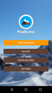
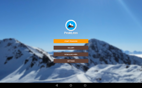


وصف لـ PeakLens
PeakLens will transform your mountain activity into an amazing experience, allowing you to get a deeper knowledge of the mountains and to create stunning photos enriched with the most accurate information about the peaks in view.
Discover the names and locations of mountain and hills around you while hiking, climbing, skiing, trekking or enjoying your favorite outdoor activity. Test your mountain knowledge and share your pictures of stunning skyline views with your friends on social networks.
FEATURES
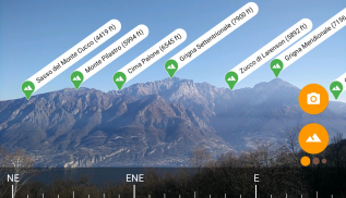
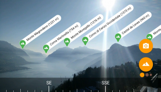
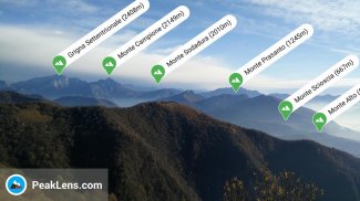
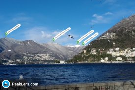
- Precisely identifies mountain peaks and hills in real-time.
- Works worldwide: from Alps, Himalayas, Rocky Mountains and Andes up to the smallest hills, anywhere on Earth.
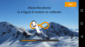
- Corrects GPS, compass, magnetometer and gyroscope errors with artificial intelligence.
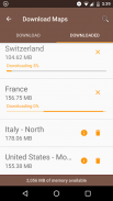
- Works online and offline with pre-downloaded maps.
- High quality photographs with peak names in overlay.
- Knows position, height and distance from you of more than 200.000 peaks.
- Works both with Imperial and Metric unit systems.
PeakLens is a novel Augmented Reality and Virtual Reality app for mountain lovers, hikers and trekkers. It is the result of years of research in artificial intelligence and computer vision, based on a novel algorithm that identifies mountain peaks in real time with high precision. Its core is a software component that compares what you actually see in the camera of your mobile phone or tablet with a virtual panorama, created from a digital 3D landscape model of the Earth. By matching what you see and the virtual panorama, PeakLens automatically corrects most errors that come from the imprecision of the compass and GPS sensor, giving you always the most accurate peak positioning.
RESOURCES
- Digital Elevation Model: the digital elevation model of the SRTM project (https://www2.jpl.nasa.gov/srtm) is used for calculating panoramic views.
- Peaks: the Peaks dataset is extracted from Openstreetmap.com.
OpenStreetMap is open data, licensed under the Open Data Commons Open Database License (ODbL).
PeakLens is a research result of Politecnico di Milano, Dipartimento di Elettronica, Informatica e Bioingegneria.
For any comments, questions or feedbacks contact us at info@peaklens.com!
سوف PeakLens تحويل النشاط الجبل بك إلى تجربة مذهلة، مما يسمح لك للحصول على معرفة أعمق من الجبال وخلق صور مذهلة المخصب مع أدق المعلومات حول القمم في الرأي.
اكتشاف أسماء ومواقع الجبال والتلال من حولك أثناء السير أو التسلق والتزلج والرحلات أو تتمتع النشاط في الهواء الطلق المفضلة لديك. اختبار المعرفة الجبل ومشاركة الصور الخاصة بك من مناظر خلابة أفق مع أصدقائك على الشبكات الاجتماعية.
الميزات
- يحدد بالضبط قمم الجبال والتلال في الوقت الحقيقي.
- يعمل في جميع أنحاء العالم: من جبال الألب، جبال الهيمالايا، وجبال روكي جبال الأنديز حتى أصغر التلال، في أي مكان على الأرض.
- يصحح GPS، بوصلة، المغنطيسية وجيروسكوب الأخطاء مع الذكاء الاصطناعي.
- يعمل على الانترنت وغير متصل مع الخرائط تحميلها مسبقا.
- الصور عالية الجودة مع أسماء الذروة في تراكب.
- يعرف موقف والطول والمسافة منك أكثر من 200،000 القمم.
- يعمل مع كل الأنظمة حدة امبريال ومتري.
PeakLens رواية المضاف الواقع والتطبيق الواقع الافتراضي لعشاق الجبل، المتجولون والرحالة. وهو نتيجة لسنوات من البحث في مجال الذكاء الاصطناعي والكمبيوتر الرؤية، بناء على خوارزمية الرواية التي تحدد قمم الجبال في الوقت الحقيقي مع دقة عالية. جوهرها هو أحد مكونات البرنامج الذي يقارن ما تراه في الواقع في الكاميرا من هاتفك المحمول أو الجهاز اللوحي مع بانوراما الظاهري، التي تم إنشاؤها من نموذج المشهد 3D الرقمي للأرض. عن طريق مطابقة ما تراه وبانوراما الظاهري، PeakLens تلقائيا بتصحيح معظم الأخطاء التي تأتي من عدم الدقة من أجهزة الاستشعار البوصلة وGPS، مما يتيح لك دائما ذروة المواقع الأكثر دقة.
مصادر
- الارتفاع الرقمي نموذج: نموذج الارتفاع الرقمي للمشروع SRTM (https://www2.jpl.nasa.gov/srtm) يستخدم لحساب مناظر بانورامية.
- قمم: يتم استخراج بيانات قمم من Openstreetmap.com.
خريطة الشارع المفتوح هو البيانات المفتوحة، مرخص بموجب البيانات المفتوحة العموم المفتوحة الترخيص قاعدة البيانات (ODbL).
PeakLens هي مؤسسة بحثية نتيجة البوليتكنيك ميلانو، Dipartimento دي الكترونيكا، تكنولوجيا المعلومات، ه Bioingegneria.
لأي تعليقات أو أسئلة أو ردود الاتصال بنا على info@peaklens.com!
PeakLens - إصدار 2.0.8
(03-11-2023)PeakLens - معلومات APK
نُسخة APK: 2.0.8الحزمة: com.peaklens.arتطبيقات من الفئة نفسها
قد يعجبك أيضًا...


